


St. Michael Precinct, Nome Census Area, Alaska
About
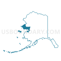
Outline

Summary
| Unique Area Identifier | 523466 |
| Name | St. Michael Precinct |
| County | Nome Census Area |
| State | Alaska |
| Area (square miles) | 1,745.70 |
| Land Area (square miles) | 1,510.50 |
| Water Area (square miles) | 235.20 |
| % of Land Area | 86.53 |
| % of Water Area | 13.47 |
| Latitude of the Internal Point | 63.28110330 |
| Longtitude of the Internal Point | -161.80454570 |
Maps


Graphs
Select a template below for downloading or customizing gragh for St. Michael Precinct, Nome Census Area, Alaska


Neighbors
Neighoring Voting District (by Name) Neighboring Voting District on the Map
- Grayling Precinct, Yukon-Koyukuk Census Area, AK
- Kaltag Precinct, Yukon-Koyukuk Census Area, AK
- Kotlik Precinct, Wade Hampton Census Area, AK
- Marshall Precinct, Wade Hampton Census Area, AK
- St. Mary's Precinct, Wade Hampton Census Area, AK
- Stebbins Precinct, Nome Census Area, AK
- Unalakleet Precinct, Nome Census Area, AK
Top 10 Neighboring County Subdivision (by Population) Neighboring County Subdivision on the Map
- Nome census subarea, Nome Census Area, AK (9,492)
- Wade Hampton census subarea, Wade Hampton Census Area, AK (7,459)
- McGrath-Holy Cross census subarea, Yukon-Koyukuk Census Area, AK (1,058)
Top 10 Neighboring Place (by Population) Neighboring Place on the Map
Top 10 Neighboring Unified School District (by Population) Neighboring Unified School District on the Map
- Lower Yukon School District, AK (6,014)
- Bering Strait School District, AK (5,894)
- Iditarod Area School District, AK (1,102)
Top 10 Neighboring State Legislative District Lower Chamber (by Population) Neighboring State Legislative District Lower Chamber on the Map
- State House District 39, Bering Straits, AK (15,642)
- State House District 6, Interior Villages, AK (14,235)
Top 10 Neighboring State Legislative District Upper Chamber (by Population) Neighboring State Legislative District Upper Chamber on the Map
Top 10 Neighboring 111th Congressional District (by Population) Neighboring 111th Congressional District on the Map
Top 10 Neighboring Census Tract (by Population) Neighboring Census Tract on the Map
- Census Tract 1, Wade Hampton Census Area, AK (7,459)
- Census Tract 1, Nome Census Area, AK (5,725)
- Census Tract 4, Yukon-Koyukuk Census Area, AK (1,058)